BEE APR 2020
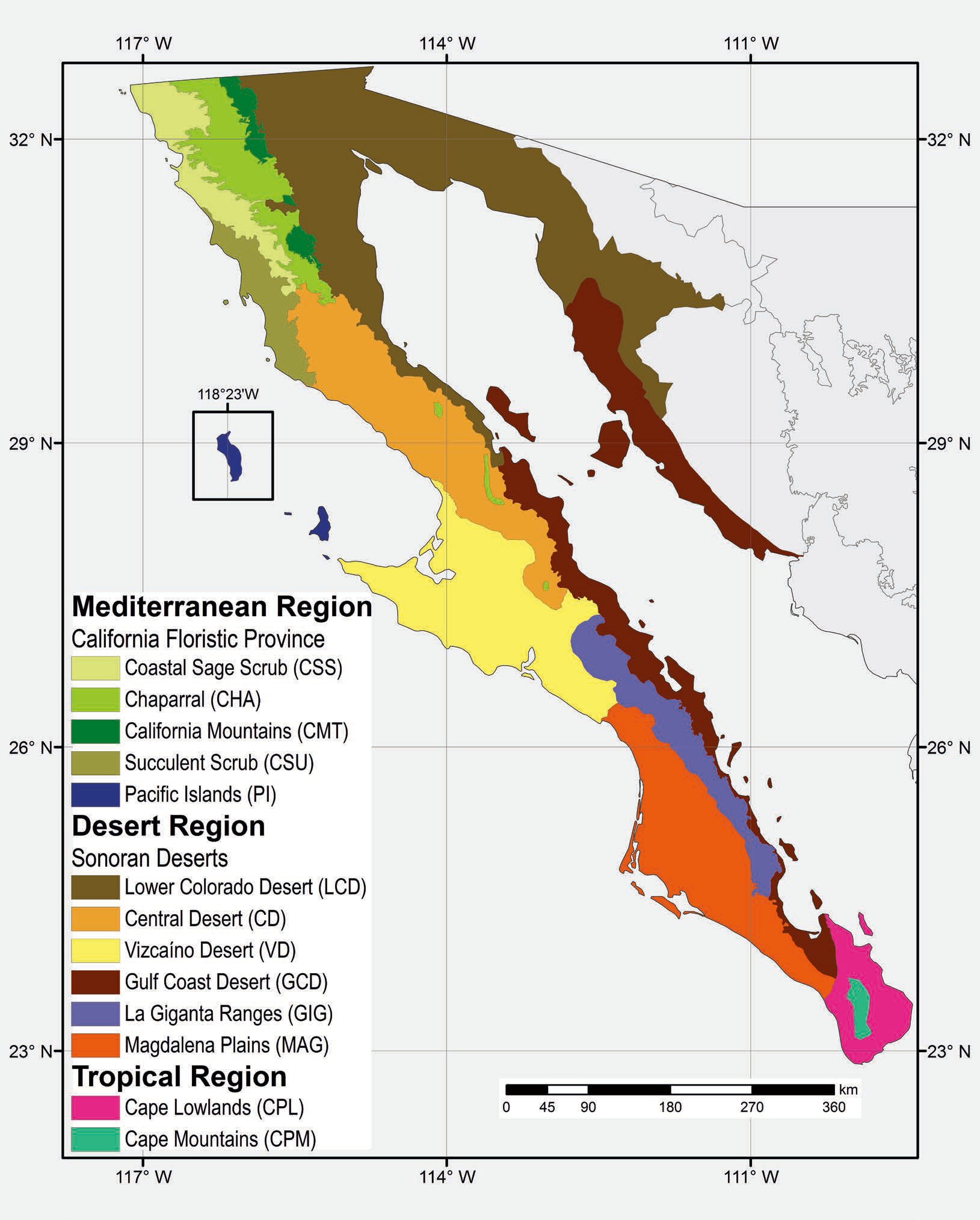
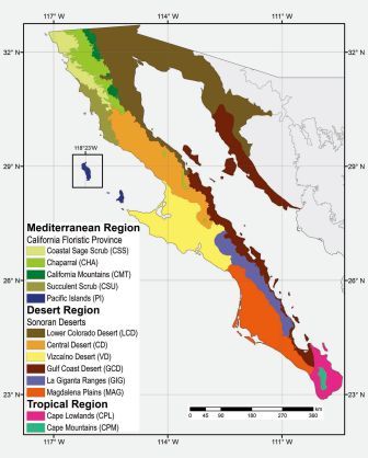
The Central Desert and the Lower Colorado Desert
 This month, I continue the trip made in late January north from Mulegé towards the border. It resumes from just north of Guerrero Negro and heads east at Laguna Chapala and north again along the Gulf Coast to beyond San Felipe.
On this leg of the trip we passed through three of Baja California’s 13 ecoregions in one day: the Vizcaíno, Central and Lower Colorado Desert ecoregions.
From Guerrero Negro, we drove approximately 2 hours to Laguna Chapala, before turning off the transpeninsular highway onto Mex. 5. This is a new section of paved highway, that not long ago extended from the international border southward, ending just south of Puertecitos. The stretch between there and Laguna Chapala was a very rugged, graded dirt road.
 We hadn't been to San Felipe since 1992 and everything has changed do much. At that time, we had made a day trip from San Felipe south to see Puertecitos via the newly paved segment of road. We didn´t get much farther than a mile or two south of Puertecitos before we turned back, worried we´d break an axle or get a flat tire on the sharp rocks of what seemed like a track heading towards Laguan Chapala. Now, all but a few kilometers of that section are paved and in excellent condition. Even the temporary dirt detours are better than in 1992.
The scenery was spectacular, with stark volcanic hills and canyons, as well as sandy, granitic arroyos and boulder fields reminiscent of Cataviña, located just on the other side of the peninsular ranges to the west.
Central Desert
Just north of the town of Guerrero Negro, we crossed into the state of Baja California at the 28th Parallel, and about 40 minutes later entered this ecoregion north of the small town of Villa Jesús María as the road climbs gradually and leaves the Vizcaíno Plain behind.

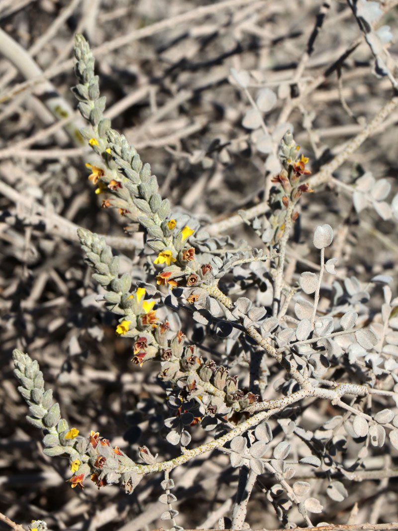
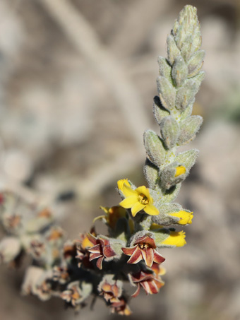
Purpus Senna (Senna purpusii) is an endemic shrub, found along the Pacific side from around El Rosario BC southward to Bahía Asunción BCS. It is not very common, and is inconspicuous until it blooms.

The leaves are somewhat leathery and glaucous. The flowers are 1.5-2 cm D and 5-petaled, the lower two cupping the stamens and style.

A roadside sunflower (Encelia sp.). Many of the Encelia in this region are known to easily hybridize.

Sunflowers lined the highway in this area just south of Ejido Nuevo Rosarito.

Deerweed (Acmispon glaber, Fabaceae), a common plant here in the Central Desert just north of the town of Punta Prieta. There are several varieties in BC.

Deerweed (Acmispon glaber) flowers are c. 2 cm L. The fruit is a long, narrow purplish-red bean about 4-5 cm L.
Highway 5 - Laguna Chapala to the Gulf Coast

A low hill on the NE side of Laguna Chapala. I was captivated by the layering of colors on the plains and hillsides in this area. It was a theme that would continue over the mountains and along the Gulf.

On this and a few other hillsides around Laguna Chapala, there were hundreds upon hundreds of barrel cactus of varying sizes. They are likely Red-spined Barrel Cactus / Biznaga (Ferocactus gracilis var. gracilis), a common endemic species in the Central Desert.

In the Laguna Chapala basin the vegetation consisted mainly of Creosotebush (Larrea tridentata), San Diego Bur-sage (Ambrosia chenopodiifolia) and White Bur-sage/Huizapol (A. dumosa) with a few small Mesquites (Prosopis sp.) seen here mid photo.

San Diego Bur-sage (Ambrosia chenopodiifolia, Asteraceae).
Basin Ranges. At Laguna Chapala Hwy 5 heads east and north. East of the lake basin, the begins to climb into the mountains that form part of the peninsula's backbone. Once over the divide, the highway descends along a wide arroyo and the alluvial fans that empty into it, eventually reaching the Gulf coast.
The dominant species on the hills include: Torote Blanco or Elephant Tree (Pachycormus discolor var. pubescens, Anacardiaceae), the largest trees seen in the photos both above and below; Ocotillo (Fouquieria splendens, Fouquieriaceae); Creosotebush; Garambullo or Old-man Cactus (Lophocereus schottii), Cardón (Pachycereus pringlei), several cholla species (Cylindropuntia spp.); Brittlebush or Incienso (Encelia farinosa); and Bur-sage/Huizapol (Ambrosia dumosa and maybe A. chenopodifolia).

Boulder-strewn hills separating the Central Desert region from the Lower Colorado Desert region and the Gulf. The rock in this area is mainly tonalite, a type of igneous rock.

At the higher altitudes in the mountains, the hills have a wide variety of species, similar to those found on the west side of the range around Cataviña, where the terrain is similar.

Eastern flank of the range separating the Central and Lower Colorado deserts. The road descends and follows a branch of Arroyo Las Arrastras.

Looking down into a gully from the highway. Ocotillo, Garambullo, Cholla, Torote Blanco, Incienso and Bur'sage. The red spots are the feathery flowers of Fairy Duster (Calliandra californica, Fabaceae).

More of the bajada vegetation as we descend Arroyo las Arrastras.

A small gully cuts through the tonalite capped with a volcanic overlay. The gully was carpeted with sprouts of Pygmy Gold-Poppy and Cryptantha.
The Lower Colorado Desert
Along this area, the ecotone between the Central Desert of the mountain range and the Lower Colorado was evident and vegetation became increasingly more sparse and less diverse as we descended the arroyo floor.

The Ocotillo (Fouquieria splendens) were leafy. There were a few with flowers & many with buds.

Torote Blanco began to thin out. Creosote, Ocotillo & Bur-sage were most abundant, with a variety of other smaller shrubs & small cacti.

Pygmy Gold-Poppy (Eschscholzia minutiflora subsp. minutiflora, Papaveraceae), a native annual.

The 4-petaled flowers of Pygmy Gold-Poppy are c. 1 cm D. The dissected leaves are glaucous. Plants were mostly under 20 cm H.

Pygmy Gold-Poppy (Eschscholzia minutiflora subsp. minutiflora, Papaveraceae)

View to the east across Arroyo Las Arrastras. A ridge of tonalite boulders runs across the valley floor in the middle distance.

Looking west across Arroyo las Arrastras & the mountains of the peninsula´s eastern escarpment. Vegetation is thinning out. The bajada is rotted tonalite, a coarse-grained sand.

From the same spot (L), looking east to the Sierra de San Francisquito across Arroyo las Arrastras. Tonalite hill with sparse vegetation.

A few Ocotillos had flowers. The low hills are becoming increasingly bare as we descend the arroyo. The near hill is tonalite thinly capped with lava.

Looking westward across the bajada filled with Ocotillos and Elephant Trees (Torote Blanco), towards Punta Final and the Sierra San Francisquito.

Where an arroyo ends in the Gulf north of Bahía San Luís Gonzaga and opposite Isla San Luís. Creosote, Bur-sage and Brittlebush are dominant.

Less than a km north of the previous photo, the vegetation changes, with scattered Elephant trees (Bursera hindsiana; reddish here) as well as Cheeseweed (Ambrosia salsola, Asteraceae), the bright yellowish shrubs)...

...and Torote blanco (Pachycormus discolor var. pubescens) seen here in the foreground.

At about the middle of a series of cuestas (grades). The closest island is El Huerfanito (the little orphan).
The Central Gulf Coast ecoregion (where we are based in Mulegé) is described as being characterized primarily by barren hillsides. So we couldn´t help but laugh at that misleading description as we drove through this ecoregion that had hillsides that were actually barren, appearing totally denuded from a distance. It wasn´t until we got much closer that there were even signs of life. The dried up plants in most cases just blended in to the surrounding rocks. By comparison, the hills around Mulegé and southward are jungles! At least we actually have trees on our hills!

The most visible plants were dormant Brittlebush (Encelia farinosa), their gray to gray-green mounds dotting the hillsides.

Every so often, we were surprised by a Brittlebush in full bloom, usually right along the edge of the road. Otherwise, the hills looked like this.

The tallest plants along this stretch near the coast were Ocotillos (Fouquieria splendens).

In the right light, if you squinted, these rocky, undulating desert hills looked like a late summer grassland in central California.

A pleasant surprise on la Cuesta de Araiza: a number of bright green low perennials that turned out to be the rare geographically restricted endemic San Felipe Buckwheat (Eriogonum galioides, Polygonaceae).

San Felipe Buckwheat. It is known to occur between San Felipe and Bahía San Luís Gonzaga. Galioides refers to its resemblance to the genus Gallium. The leaves are reflexed and spine-tipped.
While much of the desert hills, plains, dunes and washes were extremely dry and didn't appear to have much of anything actively growing on them, occasionally we came across an unexpected gem or two.

Gulf Dunebroom (Errazurizia megacarpa, Fabaceae) is a low shrub common in sandy and rocky soils. The herbage is white-tomentose and glandular with a strong odor. The leaves are pinnate.
The older, spent flowers of Gulf Dunebroom are reddish-brown, perhaps signaling to pollinators to bypass them. It ranges from this region S to Santa Rosalía. [1]

Pygmy-Cedar / Romero del Desierto (Peucephyllum schottii, Asteraceae). Contrasting with the typically tomentose, grayish-green plants such as Errazurizia megacarpa (previous), this plant was an occasional vibrant point of green in both arroyo bottoms and on flats.

Pygmy-Cedar deals with the hot, arid conditions by having a resinous coating on its needlelike leaves, a rounded habit, and an open structure below its outer, tightly packed leaves. (Peucephyllum schottii, Asteraceae).

A granitic, sandy wash about 19 km south of San Felipe. Common are Smoke tree, Cheesebush, Desert Lavender, Sweetbush (Bebbia juncea), and Brittlebush.

Desert Lavender (Condea emoryi, Lamiaceae). Leaves are tomentose, glandular, and fragrant when rubbed or crushed. The calyces are usually tomentose to densely lanate.

Brittlebush (Encelia farinosa, Asteraceae) with old flower inflorescences and newly sprouting leaves.

Flowers of Cheesebush (Ambrosia salsola, Asteraceae). Apparently the common name was coined because the crushed leaves smell like cheese. We crushed away and were left wondering, what kind of cheese was it supposed to smell like?

In many areas, the desert floor showed signs of newly sprouting annuals, like this Cryptantha (Johnstonella sp., Boraginaceae).

Drying and dead annual Cryptanthas like this endemic species (Johnstonella grayi) were also abundant across the region.

A large, healthy specimen of Ground-cherry (Physalis sp., Solanaceae) in a sandy arroyo filled with mostly dormant plants.

Smoke tree (Psorothamnus spinosus, Fabaceae) is common in the sandy washes and the bare, grayish branches look like puffs of smoke from a distance. The pea-shaped flowers are small and deep violet.

Cat's Claw Acacia / Gatuño (Senegalia greggii, Fabaceae). Seen intermittently on flats and sandy arroyos.

Cat's Claw Acacia / Gatuño (Senegalia greggii, Fabaceae). Flowers are a yellow, cylindrical raceme 2-4 cm L.

Dunes south of San Felipe. The majority of plants are Mormon Tea / Canatillo (Ephedra aspera, Ephedraceae). Foreground plants: Cheesebush.

A Creosotebush-Bur-sage community with some Ocotillos. The Sierra Juárez are in the distance, with Picacho del Diablo, the highest peak on the peninsula at 10,157 ft.

Sandy plain just S of San Felipe. Mormon Tea / Cañatillo at center.

Male flowers of California Croton / Vara Blanca (Croton californicus, Euphorbiaceae). The leaves were minute and much more linear compared to those on plants found Mulegé beach dunes.

Leafy Ocotillo on the dunes just south of San Felipe. The sand is coarse-grained alluvium (tonalite?) from the mountains.

Dried up annual Wooly Plantain (Plantago ovata, Plantaginaceae) plant. Most of the biomass on the plains seemed to be dead annuals or dormant shrubs.

Update July 2021: Initially, this was unknown, but I suspected that it might be an evening-primrose. After seeing other similar plants farther north and investigating on iNaturalist, this seems to be Chylismia claviformis var. piersonii. These sprouts were springing up all over the flats around San Felipe.

A lone open flower on the only raceme of this spindly Parry Dalea (Marina parryi, Fabaceae) found in a sandy wash near San Felipe. By comparison, around Mulegé it is currently blooming madly after the numerous rainy days we've had since November.

The Sierra las Pintas (Painted Hills) jut out into the Salinas de Omtepec, a supertidal flat here in the Upper Gulf north of San Felipe.

The Sierra las Pintas close to the highway. Wonderful colors and textures. According to Minch et al. (1998) [2] they are "formed by a sequence of Tertiary volcanics" and are highly mineralized.

Dunes on the NE foothills of the Sierra las Pintas. The dunes were formed by sand carried by wind off of Laguna Salada to the NW (Minch et al., 1998) [2].

Laguna Salada. At this point as it leaves the foothills of the Sierra las Pintas, the highway crosses a 13.5 mile open stretch of levee with mudflats on either side before it reaches the edge of the Sierra Mayor. From the highway, the basin extends 65 miles NW between the Sierra Cucupa/Sierra Mayor on the eastern shore and the Sierra de Juarez peninsular range on the western shore.

The Sierra Mayor just south of the small town of Cucupá located on the Rio Hardy.
As I wrote last month, what an amazing trip! The scenery between Laguna Chapala and Mexicali, much of it along the Gulf Coast, was absolutely beautiful in its austerity and in its geological formations, plants, and the striking color variations as of result of the interplay between vegetation and geology. It was a stark contrast between the superbloom unfolding all across the Vizcaíno Desert, but no less spectacular.
Right now, with the concern about the Coronavirus increasing (that so far has a very low known incidence on the peninsula), we are all following social distancing precautions. Nonetheless, I hope to get out to commune with nature as much as I can. I hope you enjoyed this month's entry and will join me next time for a hit of nature and the outdoors. Wishing you all good health. Until next month, hasta pronto…
Debra Valov—Curatorial Volunteer
References
[1] Kelt, D. A. (197). Floral color change in Errazurizia megacarpa, a sonoran desert shrub.
Canadian Journal of Botany, 1997, 75(6): 955-959, https://doi.org/10.1139/b97-1065 [go back to citation in text]
[2] Minch, J., E. Minch and J. Minch (1998). Roadside geology and biology of Baja California. Mission Viejo, CA: John Minch and Associates, Inc. [go back to citation in text]
Rebman, J. P., J. Gibson, and K. Rich, 2016. Annotated checklist of the vascular plants of Baja California, Mexico. Proceedings of the San Diego Society of Natural History, No. 45, 15 November 2016. San Diego Natural History Museum, San Diego, CA. Full text available online.
Rebman, J. P and Roberts, N. C. (2012). Baja California Plant Field Guide. San Diego, CA: Sunbelt Publications. Descriptions and distribution.
Wiggins, I. L. (1980). The Flora of Baja California. Stanford University Press. Keys and descriptions.