BEE JAN 2015
Baja California Norte: lichens y flowers; Hurricane Odile Aftermath
Like the California Gray Whales, we too are heading south for the Baja California peninsula. We left late this year because of the aftermath of hurricane Odile that rampaged up the Peninsula in mid-September like a bull in a china shop. The destruction this year to numerous communities from Cabo San Lucas (in BCS) to Bahía de Los Angeles in Baja California (Norte), has been devastating to both the landscape and the economy of the Peninsula.
Field Notes — Nov 17-18, 2014
Mulegé, the small town where we've spent part of the year since 1995, experienced its seventh major flood, just since 2001. Before that, the last major flash flood occurred in 1959. Coming at a rate of one every 2 to 3 years now, the town barely has time to get back on its feet before the carpet is pulled out from under it again. Add to that the downturn in the world economy beginning in 2008 and bad PR regarding narco-trafficking in Mexico, and the result has been a major, widespread loss of tourism for all here.
Hurricane Odile brought rain to the lower two-thirds of the peninsula and if I recall correctly, the edge of the cloud cover even reached as far north as San Diego. The drive down yesterday and today to Guerrero Negro BCS, located just a few miles south of the state border at the 28th Parallel, was through an unexpectedly green landscape. Pockets of dry, gray or blackened vegetation would be suddenly replaced with swaths of green, demonstrating the capricious nature of rain in the desert.

Area of drier vegetation with the occasional flowering Coastal Agave (Agave shawii).

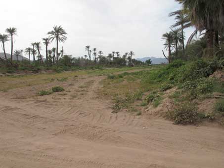
Lots of greenery, within 20 mi. of previous photo in northern BC.
Our first pit stop was along the highway near the Km. 44 marker south of San Quintín, right where the highway turns away from the coast and heads inland towards El Rosario. Some of the last remaining patches of intact coastal rosette scrub can be found there. Much of the area between the highway and coast all along this stretch is composed of extensive sand dunes, while to the east of the highway are ancient marine terraces. Where undisturbed, dense coastal scrub thrives, but in most areas it is already being heavily impacted by development plans (i.e. areas are being bulldozed and cleared for future sale, though there is practically no actual work being done).
TerraPeninsular has been able to protect some land on the east side of the highway for a reserve they call Valle Tranquilo. It includes the eastern flanks of some of the ancient marine terraces. If you are interested, here is a link to a short description of their mission and a 12 minute video about their projects in the San Quintín area.
This past summer, I attended a half-day workshop on lichens at the Botanical Garden in Tilden Park. So, I was ready to check out what lichens were growing along the coast when we made our first stop. Looking from the bottom of the hill, most of the shrubs sported green, furry-looking branches. These were the hundreds of what appears to be Bark Fog Lichen (Niebla ceruchis, Ramalinaceae).

Foreground shrub is a Cliff Spurge (Euphorbia misera) covered with dense clusters of Bark Fog Lichen (Niebla ceruchis)

Cliff Spurge with its colony of Niebla ceruchis. The bottlebrush clusters are about 5 cm D.
Here are some much better images of this species that I was able to take.
According to The Lichen Flora of the Greater Sonoran Desert Region. Vol 2. by T.H. Nash, B.D. Ryan, C. Gries, & F. Bugartz (eds.) 2001. [Tempe, AZ], Niebla ceruchis is the most common species in this genus and only one of two lichens in the Sonoran Desert flora that forms cylindrical clusters on bark substrates. The thalli are highly variable and it is common for some populations to have a high degree of black stippling (these pictured here have minute black dots all over the surface of the thalli). The apothecia are cup-like.
 This species, whose genus name in Latin and Spanish means “fog”, thrives in the peninsula’s coastal fog belt, ranging from Ensenada all the way south along the Pacific coast to around the latitude of La Paz.
As I started up the hillside, I quickly realized that I was crunching up the ground which was totally encrusted with minute lichens and other components of a biological soil crust. I paused and carefully chose my footing so as to step only where the ground had obviously been disturbed before.
This reduced my ability to get really close to many of the plants and lichens for closer images, but I was determined not to damage any more than I had with my first few steps.

As it was, it was difficult progressing a mere 30 feet because, even walking in the tiny disturbed track just wide enough for my shoe, there were small, almost invisible Fish Hook cacti (Mammillaria sp.) hiding out on the "path", from just above ground level to about 6 inches high. How many Mamms can you count when you enlarge this photo?
And then there were what looked liked small, bright yellow tumbleweeds growing in dense patches on the ground, or out of small rocks. As the sun was trying to peak out through the heavy layer of fog, these clusters glowed against the darker hill.


They turned out to be another type of lichen, keying out to Niebla homalea (Armored Fog Lichen, Ramalinaceae). Some were very small, 3-5 cm in diameter while the larger ones were about 8-10 cm across. According to Nash et al. (2001) these lichens are well known to include soil-dwelling populations that apparently develop these tumble-weed like thalli, perhaps because it enhances their ability to harvest moisture at ground level from coastal fog upon which they depend. Stephen Sharnoff, author of the new A Field Guide to California Lichens, has more great closeup photos of this species, showing the variations in its form.

Niebla homalea, growing in the dirt. It has the more rounded, tumbleweed form, that some of the ones on rock do not.

Very small samples of Niebla homalea growing on a rock. It is apparently common for the Baja populations to have thalli with branched tips. Seen in profile, these remind me of tiny shrub forests.
In the jumble of sedimentary rocks on the hillside was a vast array of colors and patterns from more crustose and squammulose lichens, like the Silver Moonglow Lichen (Dimelaena radiata) below, right. This seemed to be the dominant lichen in the area, though there was also the bright orange, unidentified lichen seen in the images below. D. radiata is apparently fairly common on coastal rocks and is found occasionally inland, from the Mexican border to almost the tip of the peninsula. It is also widespread in southwest U.S.A., Macaronesia, the western Mediterranean and north Africa.

Colorful rocks and lichens carpeted the ground, including Silver Moonglow Lichen.

Silver Moonglow Lichen, Dimelaena radiata (Physciaceae).
Leaving the lichens and the coast behind, we headed into the desert and the Valle de Los Cirios Protected Natural Area which encompasses much of the southern 1/3 to 1/2 of the northern state. We pulled over at several places both north and south of Cataviña to see what the plants were up to.

Everything was very green here around Km. 112. The Boojum Trees (Cirio, Fouquieria columnaris) were very leafy, but past their flowering time. They are relatives of the Ocotillo (F. splendens) and are actually shrubs. Several are on the far right of the image.

Old Man Cactus (Garamabullo, Lophocereus schottii) frames the right side of the image taken looking down into a small wash. The red spot to the left is a barrel cactus, species unknown. Also from south of Cataviña.

A very lush hillside south of Cataviña. Most of the rounded gray-green shrubs are either Encelia farinosa or Ambrosia chenopodiifolia (Brittle bush and San Diego Bursage, Asteraceae), while the darker rounded ones are San Diego Viguiera (Bahiopsis laciniata, Asteraceae). Cardón (Pachycereus pringlei) are the tall cacti and there is an occasional Boojum tree in the distance along with Ocotillo visible on the horizon.

One of my favorite vistas in the Valle de los Cirios reserve in the central desert. It opens up after you top a grade just past the Km 242 marker south of Laguna Chapala. Love the layers of mountains in the distance.
Field Notes — Nov 29, 2014
After Hurricane Odile, most of the peninsula was cut off from the north for between 3 and 7 days because of damage to multiple bridges and arroyo crossings. A friend of ours from Guerrero Negro reports that the members of the ejido (agrarian cooperative) where her parents live, and that was established in the late 1950s, woke to find themselves with a raging river passing through the middle of their town. Until then they had been unaware that the town had been built in an existing arroyo bed. The river then took out about 1 km (1/2 mi.) of highway to their west.
 Transpeninsular Highway 1, washed out at Arroyo San Pedro, south of Guerrero Negro near Ejido Benito Juarez.
 When the waters receded, the extent of the damage to the road was evident. This is the only N-S highway running the entire length of the peninsula.
By the time we passed through today, a little more than 2 months later, there were very few desviaciones (detours) between Cataviña and Mulegé and we barely had to slow down through the washes that had been patched. The above stretch was narrower, and in good repair, but with no place to pull off the highway, a disappointing point for me because in a few places to the north of Vizcaíno, we saw huge patches of sand verbena on both sides of the highway in the scrubby dunes that were rendered inaccesible. Finally, south of Vizcaíno we were able to pull over when we saw a few small patches of sand verbena that were still thriving there amidst the dry, annual grasses.

Sand verbena (Abronia umbellata, Nyctaginaceae).

Inflorescences of sand verbena here are about 4-5 cm D.
While we were in contact with friends in several communities on the Peninsula in the immediate aftermath of the hurricane and had seen photos of the destruction, nothing compares with the real thing. If we weren't already depressed from the news and images before we got there, we certainly were within the first few days after arriving. Superficially, many things looked to be in pretty good shape and if a visitor new to the area were to arrive, s/he might not notice much damage. But the more we looked and remembered how things had been just this past May, the more obvious became the damage and loss to the our community's members.
Official reports state that Mulegé received 18.4 cm (7.36") of rain on the day of the storm. A local friend told us that the amount of rain in the mountains to the West of town was reported at around 40 cm, about double the amount that fell during hurricane Jimena in 2009 and caused the river to rise about 30 feet.
In comparison, in October 2013 during the passage of tropical storm Octave, during which the town was on high alert for flooding which seemed imminent but didn't occur, 9.1 cm (3.64"inches) fell, but over a 48 hour time period. This translates to twice as much rain falling during Odile in half the time, with concurrent wind speeds of up to 130 mph.
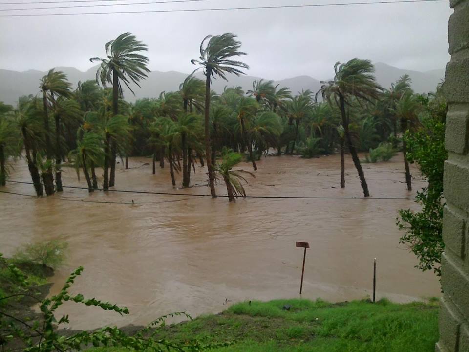
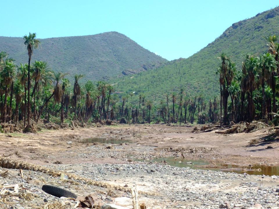
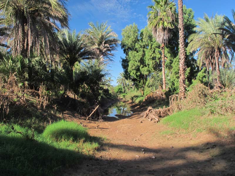
The ditch I was studying for the last two seasons was somewhere under the water within the palm trees.

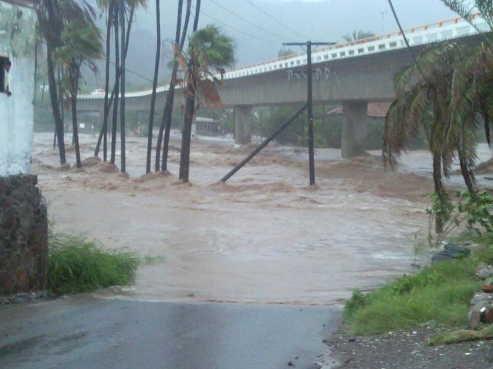
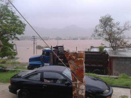
Water rising in the first hours of the flood under the highway bridge.
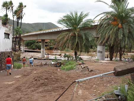
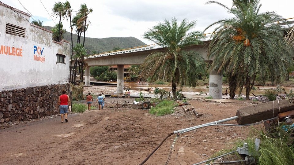
Aftermath under the bridge. The new viaduct and road under the bridge, just completed in April, was washed away again.
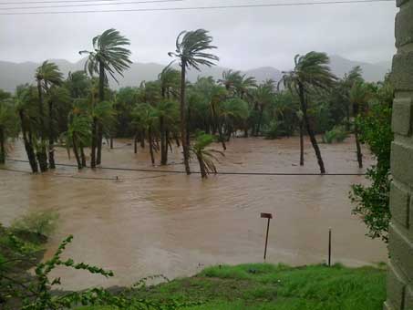
The entire valley was under water. Only houses on the hillsides escaped inundation.
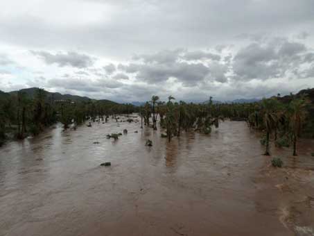
Water surging from the valley towards the bridge.
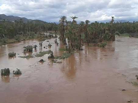
Same location as above with waters receding. The orchard underwater here is another area where I've spent a great deal of time studying and collecting plant specimens.
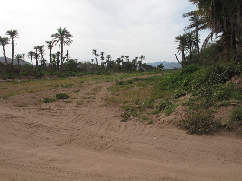
A new project in the Mulegé valley was begun this past winter-spring, in which a "canal" was being excavated to purportedly help reduce the effects of flash flooding in the valley, river and estuary by channeling the water more directly to the river outlet and reducing the flow in one of the main arroyos that always flooded outlying neighborhoods along the way.

The canal project cuts through the historic palm orchards.
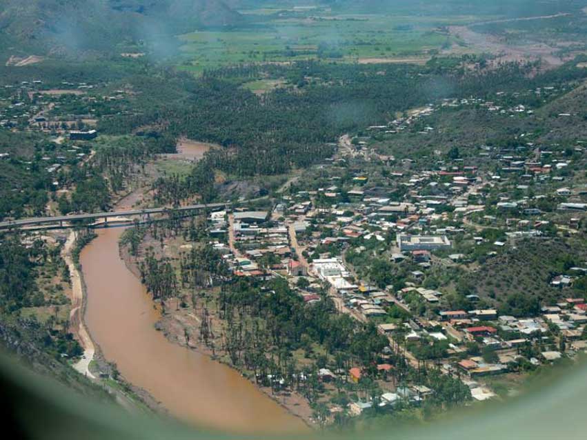
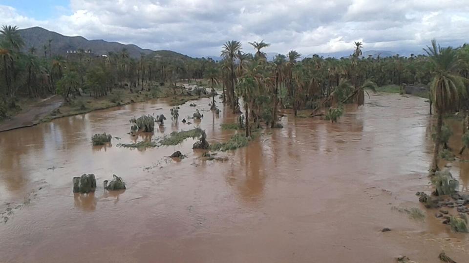
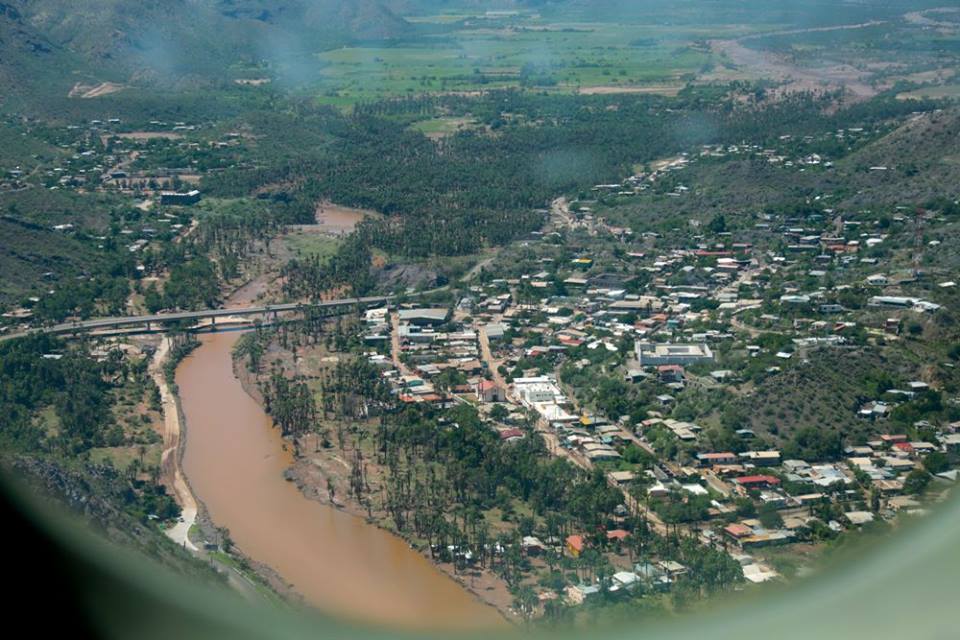
Aerial view of the town, looking west into the valley with waters receding. The bare path in the top quarter of the photo is the new canal project which extends through the palm orchard about center in the image.
The jury of local opinion is still out on whether, by bulldozing and clearing all the vegetation in the existing, meandering arroyo bed and creating a denuded swath of fine, alluvial soil about 25-30 meters wide and at least 8 km. long, the town was left more vulnerable because of the increased speed, volume and silt load that resulted. What is clear to all is that the river was flowing harder than ever before, it obliterated the earthen dams and channel out in the valley, there was a great deal more water in parts of town that had never experienced flooding, and the amount of mud left behind was unprecedented. Some people opine that it could have been worse without the “canal” and that the amount of damage was due solely to there being more rainfall in the mountains. I think we will never know definitively and the answer is probably somewhere in between.
Not all the news is totally depressing, especially from a botanical viewpoint. I can report that I have had a chance to get out into the field, even though there is a lot of damage to many of the roads which are very difficult or scary to drive on at the moment. And that on my only field trip so far, I encountered a new species for my area, not surprisingly within the shady oasis near where my ditch used to be. I haven't had the heart yet to visit the Ojo, but that's next on my list. I guess I'll be making a lot of lemonade this season...

The ditch I've been observing since Oct. 2012. It had a wonderful collection of mosses and liverworts after rains from previous years, and was being colonized by fast growing pioneer species.
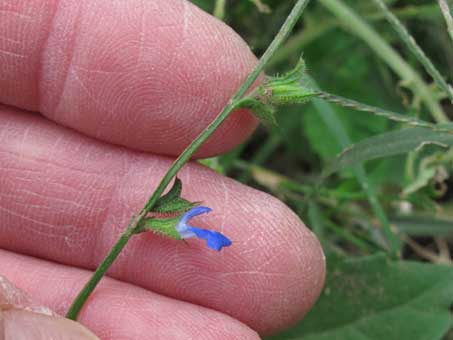
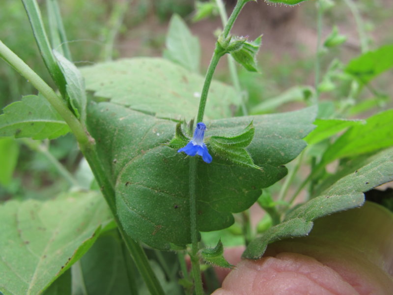
Tropical sage (Salvia misella, Lamiaceae). This is apparently a native to the tropical Americas, including Florida and Puerto Rico. It is the only Salvia species that I have encountered in this area, but Salvias are more common at higher elevations and farther north of here.
The ditch was obliterated by the canal project. But I now have a new site to observe to see which species will colonize this time around.

Found in the shady area of the remaining Oasis area, this species was undoubtedly carried downstream with the flood, since it is known from wet areas in the mountains to the west of town.
Until next month, hasta la próxima…
Debra Valov—Curatorial volunteer
 and then many of the tree-like columnar cactus Pachycereus pringlei. © D. Valov 2014")