BEE HIVE FEB 2024
 May & Nov. 2023 — Last summer, I had planned to write about the day-trip in May that my friend Javier and I made to the Sierra de Guadalupe west of Mulegé, but I never managed to get around to the task. So I'm glad now, after having recently revisited the area in November, to have the opportunity to write about both trips, and to compare and contrast the state of the vegetation on both.
Back in May, I wanted to see what was blooming at the higher altitudes when the spring blooms were just getting into full swing at sea level. I was also curious to see if there was still water in the arroyos and if there might be mosses or ferns to collect. These were the same reasons for the November trip, but in that case, I wanted to see what might be hanging around just a few months after Hurricane Kay and several other late summer rainstorms.
In May, we hit the road very early in order to beat the heat, and only went as far as the Vado de la Virgencita (see previous post) so that we could be back home well before midday. In November we headed out a little later because while it was still surprisingly warm and humid in the day, riding in the open buggy in the early morning would be quite fresh.
On that trip, we stopped first at the Virgencita, but then we continued on as far as Rancho El Aguajito for an early lunch and visit with the owners. The difference in vegetation between the two trips was almost like night and day.
We discovered that the road had recently been graded just before our May trip so the drive was fairly smooth. However, what was obvious in November was how much water there had been in the arroyos in the summer, based on how torn up the road was in some places and how some arroyos were now swept clean of all but gravel and small rocks, while others were clogged with boulders and dead vegetation. Also notable was the presence of small ponds and streams in a number of arroyo beds up at the higher elevations.
For previous Sierra Guadalupe trips, see: Apr 2013 (San José de Magdalena - SJdM); May 2014 (Pacific route to La Ballena); Jun 2015 (SJdM); Jan 2018 (Arroyo las Chuparrosas in southern valley); Jan 2019a and Jan 2019b (Sierra Zacatecas & Sierra Guadalupe via Pacific route); Jul 2020 (Arroyo San Nicolás & SJdM); and May 2021 (SJdM to Mulegé via ex-Misión de Guadalupe).
For a full list of this month's plants and animals (with family, latín name and common names in both English and Spanish), visit this page.
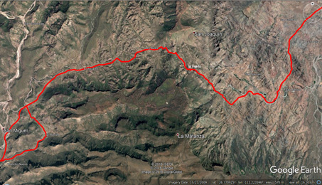
Mulegé Valley to Rancho Ingerto. The following eight sets of photos taken between the Mulegé Valley and Rancho El Ingerto (i.e. the first leg of our trips) demonstrate well how much the desert vegetation changes across the seasons, depending on seasonal moisture and temperature. Throughout the rest of this post you will find additional comparisons as well as links to the previous trips to the area for an even deeper look.


Heading directly towards the Picachos San Esteban as the road climbs into the sierras just E of the first major grade. The image at left is from May while that on the right is from November. The Picachos (peaks) are between 1970 and 2625 ft.
The climb up into the first pass in the Sierras that runs between the Picachos San Esteban (at right) and Picachos la Trinidad (on left). Compared to the smooth, easy ascent in May, there were many rocky dips & bumps. I learned a few weeks after our trip that it had just been graded. Dang.
Mesa la Mezcalera in May (left) & Nov (right). The track branching to the left of the boudler descends to San Patricio and Cañon la Trinidad. According to the topo map I have, the mesa's elevation 3280 ft.
The road west had been graded not very long before our trip in May and the roadbed was fairly smooth and wide (left). Note the tree with the white trunk in both images. In November we waited while this ranch truck crept up the rough grade before we could proceed.
Passing close alongside the bed of Arroyo San Narciso. This is a very nice, shady picnic spot. The large trees look similarly leafy in both images (May on left), but the undergrowth is fuller & the light not so harsh in Nov. The elevation along the arroyo here is around 800 ft.
Just west of the turnoff to Rancho San Narciso. What a striking difference between the two trips (May at left).
And a little farther along, having almost reached the other side of the valley (from the previous photos; May at left).
Approaching Rancho Ingerto & the next big grade. Palo Blancos aren't very leafy but have flowers & young fruit in May (left). In almost the same area a little closer to Rancho Ingerto in Nov. (right) where the Palo Blancos & most other shrubs & trees are sporting leaves in various shades of green.
As seen in the above images, the desert in May was a variation of grays and browns, only occasionally dotted with some green, or the brilliant yellow blooms of Palo Verde (Parkinsonia microphylla and P. florida), Mesquite (Prosopis articulata) or Palo Chino (Senegalia peninsularis). November's landscape by comparison was a lush forest, especially along the arroyo beds, where the leafy crowns of Palo Blancos (Lysiloma candidum), Mesquite, and Bebelama (Sideroxylon occidentale) vied for space and created areas of deep, cool shade.

May: Cardón cacti (Pachycereus pringlei) were flowering and fruiting.

Hedgehog Cactus / Biznaguita (Echinocereus brandegeei) spines catching the sunlight on a rocky hillside.

Long-spine Barrel Cactus / Biznaga (Ferocactus rectispinus) is a BCS endemic more common in the Sierras than around Mulegé. This was a small specimen growing out of a little dirt on a rocky outcrop in Nov.

The 6-7 cm long spines along the lower ribs of this Long-spine Barrel are short compared to those near its crown that were at about 20 cm L, and shorter than some I've seen on other individuals (see here & here).
Rancho Ingerto. The ranch is nestled in the narrow canyon created by the high, steep cliffs and slopes of Arroyo San Narcisito at about 985-1000 ft. Looking overhead, the large trees create a shady and green canopy between the canyon walls. In constrast, the ground is bare and dry at your feet and the vegetation is sparse in the boulder and rock-strewn arroyo bed not far below where the ranch buildings sit.

We were greeted by the ranch dog.

Nanny goats, kids and more nanny goats at the ranch.
Just past the ranch after a sharp curve the next steep grade takes you on farther west into the sierras and another drainage area. The four or five kilometers between Rancho el Ingerto and Rancho el Aguajito are filled with spectacular views and rock formations in all directions. But next stop 1-2 km uphill, the Vado de la Virgencita.

May: Just up & over that first grade, its a dip then up another, the next one paved with cement to prevent it getting ripped up or washed away.

Vado de la Virgencita can be seen above the tire at the center of the image. The road west can be seen just above it. This image is from May 2023. See same view from May 2014.
Vado de la Virgencita. On the upstream side of the road, the bed of Arroyo San Narcisito is formed by smooth slabs of volcanic rock with a series of outcrops and boulders forming the sides. About 30 meters farther up there appears to be a small dam, created when the gaps between boulders were filled with concrete. Here is a view of the upstream side taken from the road during our 2019 visit. The site is located at about 1240 ft above sea level.

May: The stream between the dam and the road looks like there's a raging torrent, but it is actually mineralization lines from the flow. There was but a trickle, the dark line near the orangish rock.

May: Sparse vegetation on one of the rock outcrops along the Vado upstream. Littleleaf Elephant Tree, Cardon, Littleleaf Palo Verde and Organpipe Cactus are the prominent species in the image.

May: Peninsula Cholla / Cholla Barbuda (Cylindropuntia alcahes var. alcahes). There are a few buds and flowers (yellow tinged with red). Can you find them?

May: Chain-link Cholla / Cholla Barbona (Cylindropuntia cholla). This & the previous cholla are common, widespread peninsular endemics. As far as I know, it's the only pink-flowered BC cholla, making ID easy.

Limberbush / Matacora (Jatropha cuneata) in in May its most common state: leafless.

May: This Organ-pipe Cactus / Pitahaya dulce (Stenocereus thurberi) isn't thriving as well as are some nearby.

May: Baja California Rock-nettle (Eucnide cordata) with its glossy but prickly leaves & greenish-white flowers. It is a common perennial herb along arroyos & seasonal pools, as well as on rock faces (or even mission walls!).

The flowers appear tubular but each of the 5 petals is actually free to the base. Hummingbirds & butterflies are common visitors to this species (both images from May). These larger plants were gone in Nov.
The differences in the vado (Spanish for gully) between our May and November trips were quite noticeable. While in November the trees and shrubs lining the banks were fuller and had fresh new leaves compared to the sparse, dusty or aging leaves of May, there seemed to be less vegetation overall in the bottom of the gully, likely due to it undergoing a scouring by water and debris coming down it during the summer storms.

Looking down into the lower part of the vado (photo from Nov. 2018) from the road. The road creates a dam over which water can flow, though much of it seeps through the cracks under the roadbed.

Nov: Looking up towards the road from the first set of pools (same as the bright green plants and rock in the middle of the image at left). The roadbed/dam and the buggy can be seen near the top.
Plants like Blue Streamwort (Stemodia durantifolia var. durantifolia), Water-Hyssop (Bacopa monnieri) and Buena Mujer (Chloracantha spinosa var. spinosissima) that were growing in the sunnier parts of the vado bottom were small in May but more lush in November. There was no sign in November of most of the small cattails (Typha sp.), all about a meter or so high, that had been growing densely around some of the pools in May, or of the mosses that had been sprouting in the dirt close to the edge of the water. The main plant that was still going strong in November was Yerba Mansa (Anemopsis californica). It was flowering even more so than in May, had developing fruit, and was sending out stolons in every direction, reaching out across the rocks and soil to colonize new territory.

Nov: Farther down the vado, looking upstream. Lush growth with some species larger than in May.

May: Looking downstream from the same location photo at left>. Javier (in blue) has reached another pool.

Nov: The most prolific species in the vado both trips had to be Yerba Mansa (Anemopsis californica).

Yerba Mansa. The leaves are fairly large, thick and somewhat aromatic. (see more high res images).

The conical inflorescence (or pseudanthium) of Yerba Mansa is 1-4 cm L and has 4-9 white, petal-like bracts at the base. Individual flowers are subtended by a smaller (3.5-6 mm L) white bract. Only a few flowers were present in May.

Nov: In this region, the plants are found along permanent & seasonal water courses. The plant readily spreads vegetatively by rhizomes and stolons, forming large, dense colonies but it also produces seeds in a tough, bouyant single fruit (above). Both flowers & fruit were present.

May: Downstream at a small pool and mini-waterfall. The dark red rock in the center is the same pictured in the next image, but from the opposite direction. The plants in the foreground are mainly Water-Hyssop and Spike-rushes (Eleocharis spp.)

May: The little pool below the dark red rock. The pool was mainly filled with a mat of algae. What was interesting was what I saw on the flat surface of the red rock in running water.

There were clusters of small dark objects that looked like the egg cases or larvae of some critter. Each was about 5 mm or so long.

May: The pond farther downstream at the end of the trail had lots of water insects. These are Whirlygig beetles (Dineutus sp.). The beetles were around 1.5 cm L.

The beetle's elytra is black with a longtudinal ridge where the two halves meet. There were hundreds of these active beetles in the pond. More Whirlygig beetle info & images.

May: The peninsular endemic Short-Tooth Monkey Flower (Erythranthe brevinasuta) occurs in many of the wet areas in the Sierras. See more images of this species from previous posts here and here.

May: The tiny Red-spotted Frog / Sapo de Puntos Rojos (Anaxyrus punctatus) is common near perennial water sources like this vado. I've seen them at various springs & likely heard them along the Mulegé River.

May: Brandegee Brickelbush (Brickellia brandegeei). Note the long, exserted stigmas on the flower.

The discoid flower head of Brandegee Brickelbush has a ±cylindrical involucre & is about 1.5-2 cm L x 4-5 mm D.

There were many blown heads of Brickelbush in November. Each cypsela (fruit) is finely barbed and ±5 mm L.

It only took until this, my third visit to the vado, to realize why this spiny plant looked so famiiar. This post from our East Cape trip in 2019 has images of the fruit and a brief discription about Snake-eyes / Putia (Phaulothamnus spinescens).

Palo Chino (Senegalia peninsularis). Seeing all these mature, curly fruits, I would hazard a guess that they are the source of the Spanish common name since "chino" is one word for "curly".

Graythorn (Ziziphus canescens var. obtusifolia) is both gray & thorny. The tips of the rigid, densely hairy stems are SHARP & dangerous. When leafless, it is just a mass of intricately branched gray branches.

Organ-pipe Cactus (Stenocereus thurberi) stem with new branch, showing the long, fine dark spines.

Lower stem of aging Organ-pipe Cactus (Stenocereus thurberi) looks almost bark-like.
The Seep. What I call the seep is a spot alongside the road where water emerges and trickles down the northfacing side of a roadcut. It is only about 800 meters uphill from the Virgencita. Javier climbed up the hill above the roadcut but said he couldn't see any water coming out farther up on the open parts of slope. It seems that the spring originates somewhere within the rocky outcrop maybe 4-5 meters (or more) above it. The spring likely feeds eventually into the Vado below along the same arroyo after crossing the road and dribbling down a narrow gully.


There was just enough water in May at the seep for it to cross the road and run downhill in the little gully where it seemed to disappear into the ground. The vegetation was pretty sparse but the stand of Peninsular Flatsedge (Cyperus dioicus) that hangs down over the the face of the roadcut was still fairly abundant. In November, the curtain of flatsedge was lush. The base of the seep was squishy and carpeted with Spike-rushes, Water-hyssop & Blue Streamwort, all partially shaded by tall numerous Tree Tobacco plants (Nicotiana glauca).

Honey bees on the seep wall, drinking or perhaps getting minerals. The face of the seep is a mixture of dirt and gravel encrusted with minerals from the water, much of it held more firmly by moss.

Carpet of Bent Spike-rush (Eleocharis geniculata), Water-Hyssop (Bacopa monnieri), Purple Streamwort (Stemodia durantifolia var. durantifolia) & a few Peninsular Flatsedges at the base.

Bent Spike-rush (Eleocharis geniculata) showing signs of flowering (click the image & zoom to see the tiny new inflorescences at the stem tips).

The seep is a microcosm of a typical aquatic ecosystem in the sierras, all within a mere 14-15 sq. meters.

May: The mossy seep wall where almost no other plants were growing, except the tougher Peninsular Flatsedge (Cyperus dioicus) & spike-rushes (Eleocharis).

Nov: The same mossy seep wall, now with many small seedlings of Short-tooth Monkeyflower (Erythranthe brevinasuta).

A clump of moss on a small rock at the base of the seep in November.

May: Seep with another Red-spotted Frog. These little creatures are quite active in the day.

Water-Hyssop / Baraima (Bacopa monnieri) at the base of the seep wall. Moss is sprouting out of the soil on the right.

Many-flower Monkeyflower (Erythranthe floribunda) is also common in the many springs in the sierras.

A small Fish-hook Cactus / Viejitos (Mammillaria dioica var. dioica). These small cylindrical cacti often have multiple pups (new stems) to form a small colony. They can often be found growing out from between rocks and are easy to overlook and/or step on. Flower image.

Baja California Agave / Lechuguilla (Agave sobria var. sobria) is a BCS endemic variety found mostly in the broader Sierra Giganta range (includes Sierra de Guadalupe) & some Gulf islands. The leaves are gen. less than 60 cm L x 10 cm W with marginal teeth.
Rancho El Aguajito and Back Down the Hill — November. The ranch is located about 42 kilometers west of Mulegé on the main road to La Ballena and the Pacific Coast but from our last location at the Seep, it's just a few more km uphill, across a valley and up and down a few more hills.

Now past the grade near the seep and heading downhill (mostly) towards Rancho el Aguajito.

One of several water holes along the way. The water is quite shallow and well-used by livestock. The edge is lined with Bermuda grass (Cynodon dactylon). Look at that greenery!

The final watercrossing before the ranch.

Same watercrossing, looking upstream.

A thick algal mata at the edge of the water.

How do they all do that, growing on and in a rocky cliff?

Very green slopes seen from the ranch. Leguminous trees (Mesquite, Palo Verde), Elephant Trees, Limberbush & Palo Adan are the primary leafy shrubs and trees.

The ranch runs cattle & goats. The higher elevation means more water & forage for the animals which range freely. They take a heavy toll on an environment highly susceptible to erosion.

Heading back, not far west of the seep and el Vado de la Virgencita.

A favorite spot: dark canyon walls contrasting with the trees.
The roots and trunks of both of these Baja California Rock Figs / Zalates (Ficus petiolaris) are partially melded into the rock, the roots infiltrating cracks then growing along fissures to anchor themselves securely. Sometimes, roots can be seen that have obviously been exposed where rock has broken away. These small to medium-sized trees can be found scattered throughout much of the southern 2/3rds of the peninsula, mainly in mountainous areas or lower elevation rocky arroyos.

May: Starting to descend the last grade E of San Patricio & into the Mulegé valley. Most leguminous shrubs & trees are almost bare.

Nov: The leguminous Mesquite, Palo Blanco, Mimosa, and Palo Verde are very leafy on this same grade.
That's it for this month. Fortunately I've been able to get out in the field most weeks since we arrived, enjoying the variety of species I've come across, o next month there should be plenty to share. Until then, hasta pronto...!
Debra Valov — Curatorial Volunteer
References and Literature Cited
Crumpton, L. 2009. Santa Rosalía to Bahía Concepción [map] in: L. Crumpton, Baja California Almanac. Topographical maps, mapas topográficos. Baja California Almanac Publishers, Las Vegas, NV.
iNaturalist. Available from https://www.inaturalist.org. (Accessed January 2024)
INEGI. Carta topográfica Año Nuevo, G12A56 Baja California Sur, Esc. 1:50,000. Pachuca, Hidalgo, México. Link [accessed Jan 2024].
INEGI. Carta topográfica El Potrero, G12A66 Baja California Sur, Esc. 1:50,000. Pachuca, Hidalgo, México. Link [accessed Jan 2024].
Rebman, J. P., J. Gibson, and K. Rich, 2016. Annotated checklist of the vascular plants of Baja California, Mexico. Proceedings of the San Diego Society of Natural History, No. 45, 15 November 2016. San Diego Natural History Museum, San Diego, CA. Full text available online.
Rebman, J. P and Roberts, N. C. (2012). Baja California Plant Field Guide. San Diego, CA: Sunbelt Publications. Descriptions and distribution.
Valov, D. (2020). An Annotated Checklist of the Vascular Plants of Mulegé, Baja California, Mexico. Madroño 67(3), 115-160, (23 December 2020). https://doi.org/10.3120/0024-9637-67.3.115
Wiggins, I. L. (1980). The Flora of Baja California. Stanford University Press. Keys and descriptions.


